JuncTry, Try to junc on map

Enhance map visualization application with digital workflow intelligence.

Functional Overview

About JuncTry

JuncTry is a full visualization workflow of map data processing.

Map digital processing

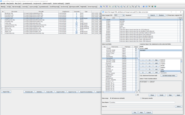
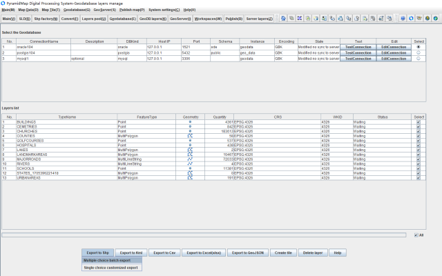
JuncTry establish the ability to design the original Shp data structure and create map data for your own business which building data conversion interoperability such as including: Shp, GeoJSON vector data; CSV and Excel structured data which have the WKT geometry cell data; Geodatabase layers and GeoServer rest services therefor achieving a wide data sources and accurate data adaptation.

Geo data storage

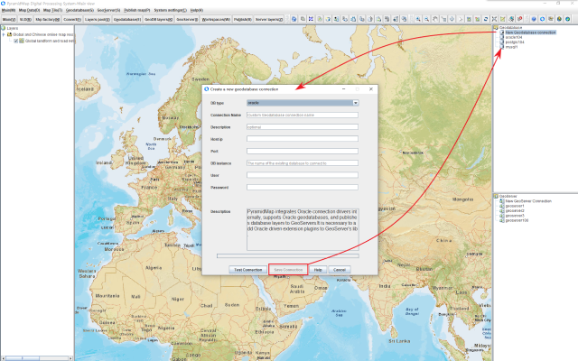
JuncTry supports but is not limited to Oracle, PostGIS, and MySQL enterprise level Geodatabases achieving to process and concurrent access capabilities of large-scale spatial data. and has given map data version and archive management capabilities. The most common model is to display business maps on web and mobile devices display map with the visual interface from GeoServer which data combining Geodatabases.

Standardized services

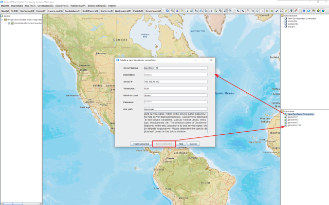
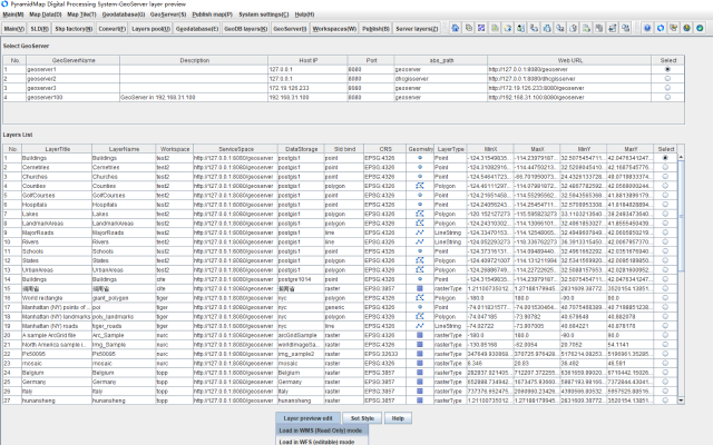
JuncTry can be working as a visualization client with more intuitive and concise UI process replacing the traditional highly specialized operation mode for GeoServer. It unifies the internal workspaces and layers of the GeoServer and outputs the standardized rest services for map displaying on the web and mobile end ultimately. JuncTry simplifies such a complex process into a smooth visual interface process.

JuncTry Digital Processing Platform

JuncTry is the production of the Shandong Raster Data Technology Co., Ltd(www.rasterunit.com) completing the map digital processing workflow. JuncTry is an independent map processing application and can also works as a GeoServer visualization client. JuncTry is a visual platform which complete map cartography, querying and editting, SLD symbol definition, data processing and conversion, vector and raster tile generation, hosting spatial data in Geodatabase and output from GeoServer. JuncTry build map visualization application more easily replacing highly specialized operations with efficient digital processes and concise visualization mode.

Email: service@rasterunit.com

Download JuncTry
Download JuncTry

Instructions for the version update

Version Date Instruction
V1.0.4 2024-05-29 Add local vector and raster layer to the independent map view which conjuncting with online map resources to provide autonomous positional references for drawing features on map.
V1.0.3 2024-05-15 Solved the problem of slow layer editing when switching between multiple layers; Adjusting index of the selected layer in the map content already layers with moving up and down to adjust visibility through node's popup menu.
V1.0.2 2024-03-20 Add one click publishing feature for GeoServer data storage layers.
V1.0.1 2024-03-02 Improve MVT and MBTiles vector tile algorithms to improve tile generation speed and accuracy.
V1.0.0 2024-02-10 First issue

JuncTry Digital Technology White Paper

The JuncTry Digital Technology White Paper provides detailed technical specifications and usage methods for you. The white paper is divided into 10 chapters, covering 10 topics including: 1. Introduction, 2. Running mode, 3. Map Display, 4. Map Rendering, 5. Query Editing, 6. Data Processing, 7. Map Tiles, 8. GeoDatabase, 9. GeoServer and 10. Publishing Map Services. Each chapter provides tutoring data and example downloads for key technical points helping you quickly understand and master the usage methods. We sincerely hope to receive your feedback, and we will continue to improve and provide higher quality services.

Email: service@rasterunit.com

JuncTry Digital Technology White Paper

Examples

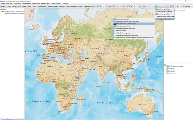
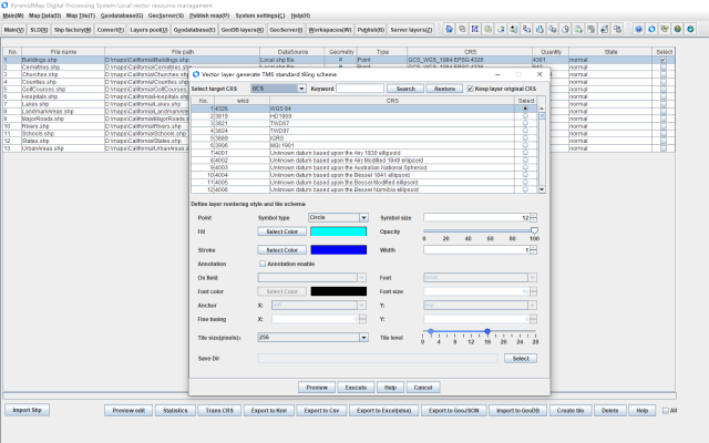
JuncTry supports creating multiple types of map tiles for vector and raster layers, including: 1 PBF vector tiles, 2 MVT vector tiles, 3 MBTiles vector tiles, 4 MBTiles raster tiles, 5 TMS raster tiles and 6 XYZ raster tiles. We will provide detailed explanations in the following sample selection examples. For more information, please refer toJuncTry Digital Technology White Paper

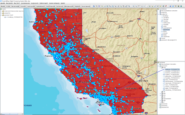
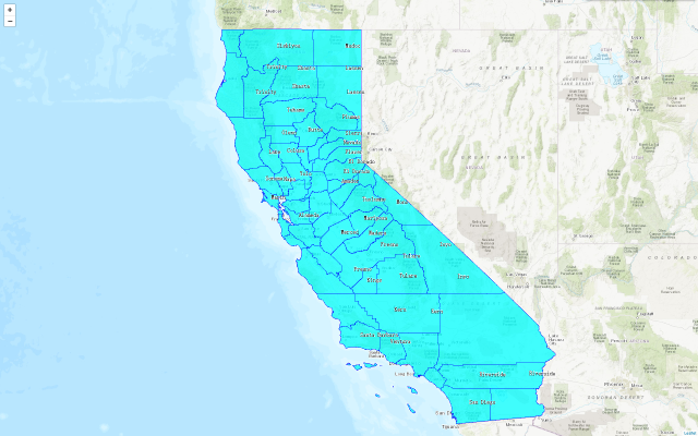
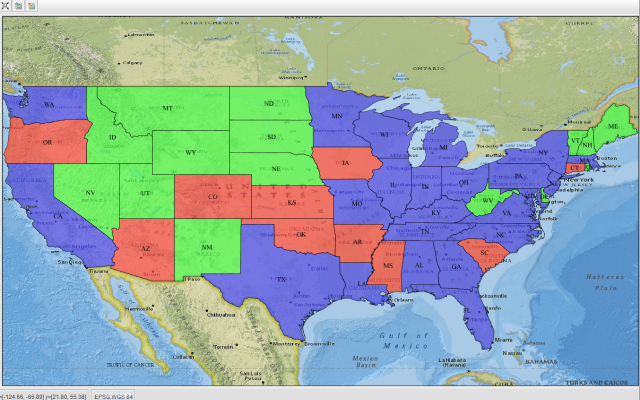
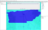
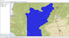
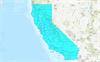
Example 1: Displaying the raster TMS tiles created on vector layer in Leaflet.

TMS (Tile Map Service) is a tile standard defined by the Open Source Geospatial Foundation (OSGeo). TMS defines tiles as starting from the bottom left corner of the map, which is the origin of the tiles and numbering system, with the y-axis (Y value) increasing from south to north. JuncTry supports generating tiles for Shp, GeoJSON and GeoDatabase vector layers for flexible offline deployment which can be integrated with projects or independently deployed to web servers such as Apache, Tomcat and Nginx detached from the professional GeoServer and accessed through URL or relative path therefore, it is possible to greatly reduce the difficulty of map deployment and project costs.

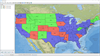
The Counties.shp in this example represents the location of counties in California, USA. The tutoring data can be download in JuncTry:Shp,GeoJSON,web example. The web example application has a complete runtime environment and can be deployed to Tomcat or other web servers for plug and play.

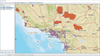
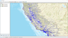
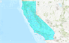
Example 2: Displaying the MVT tiles created on vector layer in Leaflet.

MVT (Mapbox Vector Tiles) is the technical specification for Mapbox's vector tiles. MVT is based on the PBF (Google Protocol Buffers) encoding format as the storage unit. For clarity, Mapbox uses the. mvt file extension, so the generation method of MVT vector tiles is exactly the same as PBF. The advantages of vector tiles are reflected in the following aspects:

  • 1. Lossless storage: Tiles are stored in PBF format based on each tile number with smaller granularity and lossless information in 256 * 256 size unit;
  • 2. Smaller volume: pbf has a higher compression rate and a smaller volume;
  • 3. Fast response speed: This is an inherent characteristic of tile data, the data returned from server according to the client's request level;
  • 4. Fast transmission speed: The data and rendering are separated, and the server only returns vector data with less data, reducing network load and improving transmission and loading speed;
  • 5. Implementing client-side rendering: Implement custom style rendering in the web client such then providing a more flexible and rich display effect;
  • 6. Implement more UI interaction: Vector tiles enable client side vectorization operations on maps, such as interactive operations, attribute and spatial queries, independent value rendering, thematic statistics, and other functions base on the feature such then making map functionality more diverse.
  • 7. Fully utilize hardware resources: Vector tiles can utilize OpenGL/WebGL drivers to adjust graphics card and memory performance, adapt to client screens, and perform high-precision vector rendering based on screen resolution. It can be said that the performance results of the same tiles are in different effects rendered on different hardware and software environment which completely depends on the display system of the client machine.
Based on the above advantages, vector tile technology has quickly gained recognition and support from a large number of map manufacturers. ArcGIS, Leaflet, MapTiler, and OpenLayers have all supported for the vector tile specifications. Of course, dialectically speaking, the cost of vector tile technology is relatively high, mainly limited by the following points:
  • 1. High technical difficulty: The usual approach is to upload the map to Mapbox studio and perform tile hosting on the Mapbox platform. This requires registering a Mapbox account and customizing tile modes, which is a complex process;
  • 2. High usage cost: The cost of generating and hosting vector tiles online is very high. Taking Mapbox Studio as an example, its service space and traffic are limited, and fees will be charged if exceeded. This is not an ideal option for ordinary users and small and medium-sized enterprises;
JuncTry can create PBF/MVT/MBFiles vector tiles locally and deploy them freely, enable producing managing and using vector tiles independently. You can bundle the tile data and programs together and access tile data through URLs or relative paths without any special configuration in web application such then processing map data greatly simplifying and improving system deployment flexibility and reducing the map project's costs.

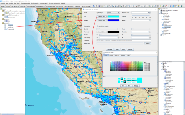
The vector layer MajorRoads.shp represents the main roads in California, USA. The tile source layer and web example can be download in JuncTry: Shp,GeoJSON,web example. The web example application has a complete runtime environment and can be deployed to Tomcat or other web servers for plug and play.

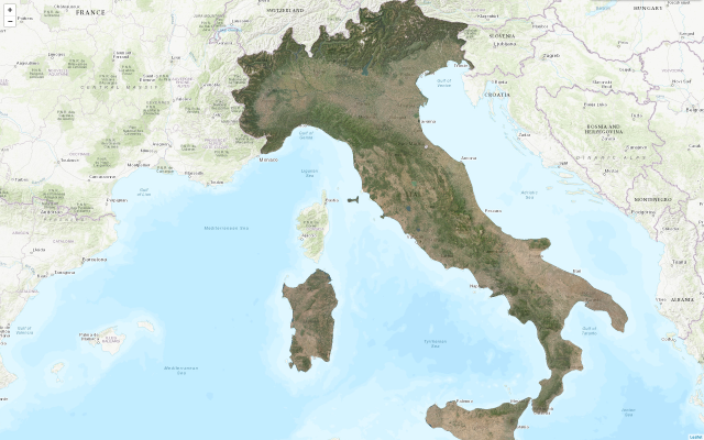
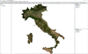
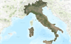
Example 3: Displaying the raster TMS tiles created on raster layer in Leaflet.

JuncTry supports creating TMS,XYZ,MBTiles tiles from raster layers.

The layer Italiy.tif in this example is a satellite panoramic image of Italy and the tutoring data can be download in JuncTry: Raster, web example. The web example application has a complete runtime environment and can be deployed to Tomcat or other web servers for plug and play.

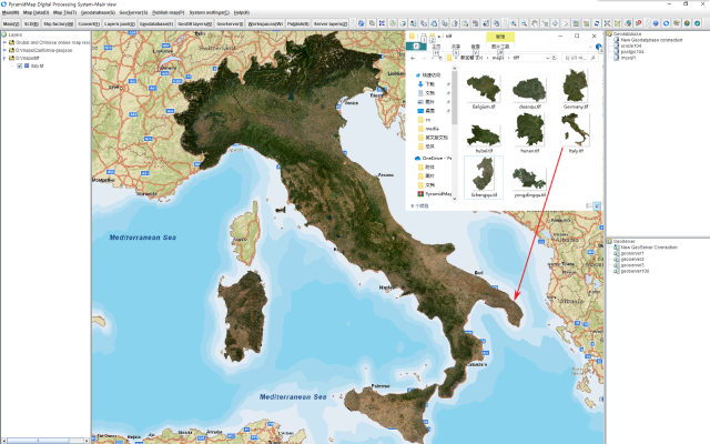
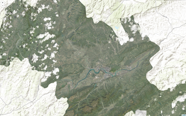
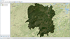
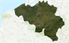
Example 4: Displaying the raster MBTiles created on raster layer in Leaflet.

MBTiles (Mapbox tiles), as the name suggests, is an open-source map tile standard hosted by Mapbox, with the goal of promoting tile map standardization and efficiency. MBTiles supports both vector and raster tiles using Web Mercator projection to describe tile coordinate data through metadata which including boundaries, latitude and longitude coordinates, etc. MBTiles internally grades tiles with create a tile dataset based on SQLite. It improves the efficiency of tile retrieval through database indexing so much higher than folder mode tiles. The original intention of MBTiles is for running map applications in embedded devices and mobile terminals by the way of storing map tiles in the local lightweight SQLite database. JuncTry supports generating MbTiles raster tiles for raster layers.

The layer Belgium.tif in this example is a satellite panoramic image of Belgium and the tutoring data can be download in JuncTry: Raster, web example. The web example application has a complete runtime environment and can be deployed to Tomcat or other web servers for plug and play.

Overview of Functions and Interface

Map display, SDL symbolS, Querying and Editing, Geo data processing, Map tiles, GeoDatabase and GeoServer applications

Tutoring data and examples

Download tutoring data and examples corresponding to each functional module

Chapter Tutoring data Example Illustrate Legend
3.2.1 Load vector layers Shp;GeoJSON Create layers resource pool through file browser or dragging method. Support Shp, GeoJSON, and rendering with SLD symbol.
3.2.1 Load raster layers Raster Create layers resource pool through file browser or dragging method. Supports raster and rendering with RGB pixel or band.
4 Rendering and symbol SLD Create or retrieve from GeoServer Support creating and editing SLD files. You can choose a layer for rendering based on the SLD geometry type. You can synchronize the SLD in GeoServer to local, or submit the local SLD to the GeoServer space.
5.1 Map querying Shp;GeoJSON Query vector layer based on attribute data. Query and highlight features of vector layer on attribute data for Shp, GeoJSON, Geodatabase, and GeoServer.
5.2 Map editing Shp;GeoJSON Create or delete vector features; Assign, modify, and delete attribute data. Edit and save features of vector layer for Shp, Geodatabase and GeoServer.
6.2.1 Vector layer preview Shp;GeoJSON Previewing in the vector resource pool or during vector data conversion process. Preview and query of multiple types of vector layers, such as Shp, GeoJSON, CSV, Excel, Geodatabase, and GeoServer in single view.
6.2.2 Raster layer preview Raster Previewing in the raster resource pool or during vector data conversion process. Preview raster layers in single view rendering with RGB or band.
6.3 Vector data processing Shp;GeoJSON;CSV;Excel Heterogeneous data transformation and data processing with vector features. Process multiple types of vector layers such as Shp, GeoJSON, CSV, Excel, Geodatabase, and GeoServer in batch or single mode. Including heterogeneous data and CRS conversion.
6.4 Raster data processing Raster Raster image data processing. Process raster layers in batch or single mode. including compression, segmentation, Mosaic merging and CRS conversion.
6.6.1 Map imported to GeoDB Shp;GeoJSON;CSV;Excel Import heterogeneous data with vector features into a Geodatabase. Import vector layers such as Shp, GeoJSON, CSV, Excel into into Enterprise GeoDB such as Oracle, PostGIS and MySQL.
7.4 Vector TMS tiles Shp;GeoJSON web example Generate TMS tiles from vector layers such as Shp or GeoJSON.
7.5 Vector XYZ tiles Shp;GeoJSON web example Generate XYZ tiles from vector layers such as Shp or GeoJSON.
7.6 Vector PBF tiles Shp;GeoJSON web example Generate PBF tiles from vector layers such as Shp or GeoJSON.
7.7 Vector MVT tiles Shp;GeoJSON web example Generate MVT tiles from vector layers such as Shp or GeoJSON.
7.8 Vector PBF MBTiles Shp;GeoJSON web example Generate vector MBTiles from vector layers such as Shp or GeoJSON.
7.9 Vector PNG MBTiles Shp;GeoJSON web example Generate raster MBTiles from vector layers such as Shp or GeoJSON.
7.10 Raster TMS tiles Raster web example Generate TMS tiles from raster layers such as GeoTiff.
7.11 Raster XYZ tiles Raster web example Generate XYZ tiles from raster layers such as GeoTiff.
7.12 Raster MBTiles Raster web example Generate MBTiles from raster layers such as GeoTiff.
10.1 Publish vector file cache layers Shp Vector file cache type Publish Shp as a file caching type service in GeoServer.
10.2 Publish raster file cache layers Raster Raster file cache type Publish raster as a file caching type service in GeoServer.
10.3 Publish GeoDB layers Shp Geodatabase type Publish vector layers such as Shp, GeoJSON, CSV, Excel and Geodatabase layers to GeoServer forming the map services.

Technical hotspots

The following technological hotspots are closely related to JuncTry and represent the development direction of GIS visualization applications

No. Item Illustrate Website
1 GDAL GDAL (Geospatial Data Abstraction Library) is an open-source conversion library for raster and vector geospatial data formats, released by the Open Source Geospatial Foundation under an MIT style open source license. GDAL has been widely used in map data underlying processing libraries, providing raster abstract data models and vector abstract data models for all supported formats, and comes with various useful command-line utilities for data conversion and processing. The GDAL standard is maintained by the OSGeo Open Source Geospatial Foundation and is continuously updated. GDAL
2 OSGeo The OSGeo(Open Source Geospatial Foundation) is a global non-profit organization that supports the development and wider application of open-source geographic and remote sensing software. Its goal is to support global cooperation, establish and promote the development and exchange of high-quality spatial geographic information software. OSGeo
3 epsg.io EPS. io provides a standardized coordinate system definition and conversion platform, covering all standardized coordinate system definitions and data conversion references. The coordinate system and projection transformation of JuncTry are based on the standardized definition of epsg. epsg.io
4 GeoTools GeoTools is an open-source Java code library based on the (LGPL) specification that provides standard methods for manipulating geospatial data. The GeoTools library implements the development of the Open Geospatial Consortium (OGC) specification. GeoTools
5 Mapbox Mapbox is currently a highly dynamic and innovative map engine manufacturer, and its vector map slicing technology has become a de facto standard in the industry. JuncTry integrates technical support for MVT (Mapbox vector tiles) and MBTiles (Mapbox tiles) internally. Mapbox
6 LeafLet Leaflet is an open source, OGC standardized map service based, web-based interactive map JavaScript engine library. The map and tile data constructed by JuncTry can be easily applied to the LeafLet development environment. LeafLet
7 OpenLayers OpenLayers is an open source, OGC standardized mapping service based, web-based interactive map JavaScript engine library. The map and tile data constructed by JuncTry can be easily applied to the OpenLayers development environment. OpenLayers
8 Cesium Cesium is an open source, OGC standardized map service based, web interactive map JavaScript library, and is currently the mainstream 3D map engine. The 2D map and tile data constructed by JuncTry can be easily applied to the Cesium development environment. Cesium
9 ArcGIS ArcGIS is an established commercial version of geographic information technology manufacturer, and its data format is also the current de facto data standard, such as shp, gdb, mdb. JuncTry's vector map data constructed based on shp format is suitable for the vast majority of map platforms. ESRIArcGIS Online
10 Oracle Oracle provides enterprise level spatial geographic data storage and processing capabilities, supporting concurrent requests for large-scale map data. JuncTry supports storage access to Oracle geodatabases, including importing and exporting vector layers, as well as serving as a GeoServer data source for layer publishing services. Oracle
11 PostgreSQL PostgreSQL is a powerful open-source relational database system that provides enterprise level spatial geographic data storage and processing capabilities, supporting concurrent requests for large-scale map data. JuncTry supports storage and access to PostGIS geodatabases, including importing and exporting vector layers, as well as serving as a GeoServer data source for layer publishing services. PostgreSQL
12 MySQL MySQL is a powerful open-source relational database system that provides enterprise level spatial geographic data storage and processing capabilities, supporting concurrent requests for large-scale map data. JuncTry supports storage access to MySQL geodatabases, including importing and exporting vector layers, as well as serving as a GeoServer data source for layer publishing services. MySQL
13 GeoServer GeoServer is an open-source map server based on the standard OGC protocol, with functions equivalent to ESRI's ArcGIS Server. It can implement standard protocol map services such as Web Feature Services (WFS), Web Map Services (WMS), and Web Coverage Services (WCS). Other formats and publishing options can be provided as extension modules, including Web Processing Services (WPS) and Web Map Tile Services (WMTS). JuncTry can serve as a visualization map processing client for GeoServer, completing the processing of the server's internal workspace and data storage, achieving the visualization process of vector and grid map publishing, greatly simplifying complex map processing work. GeoServer

JuncTry aims to provide a standardized map service process based on OSGeo helping you complete complex map processing tasks easily and obtain the complete GIS data processing capabilities to achieve map visualization development independently.

Contact us

We love pretty much to hear from you

086-0531-82957588

service@rasterunit.com

Room 2907, Building 1, Dahua Longyue Building, No. 587 Shunyi Road, Jinan Area, China (Shandong) Pilot Free Trade Zone